The objective of the SUMP Competitions was to bring the message of sustainable mobility and its benefits to all the citizens in the three cities implementing the project, and motivate them to improve their knowledge on the subject, using the medium of a public competition. The competition was aimed at culminating the campaign on SUMP undertaken by the Task Force in each city, and starting a dialogue both in formal education and among the public more generally about SUM and how it affects the everyday quality of life.
A call for a competition in each city was announced after the UrbanSCOPE digital tools were finalised. The participants were invited to use the UrbanSCOPE digital tools (MEES platform and optionally Siftr) to map existing SUM infrastructure and issues regarding a certain route in their city, and create their own “best solutions” for sustainable mobility routes and travel means, leading to their own proposals for at least 3 alternative “SUM scenarios” for that route, employing different combinations of transport means and proposing the infrastructure and planning interventions to support them.
The competition was open to university students (especially in Darmstadt and Gyor) and to secondary schools (in Glyfada), as well as any person from the public who would be interested to join (with the exception of SUM experts like urban planners, transport engineers etc.). The competition was announced by the local authorities of the three cities and the project partners, and detailed instructions were offered online, as well as application forms and the methodology and course material of UrbanSCOPE for universities, schools and adult audiences. The participants were encouraged to consult the learning material that is suitable for them, and then embark on the competition.
Basically, the competition participants needed to follow the next 4 steps in order to submit a competition entry:
| STEP 1 | Think of a route you would like to examine in your city and define the starting point (A) and the destination (B). For example the starting point A can be your home or a meeting place in your neighbourhood, and your destination B can be your school or the city centre. It’s up to you! |
| STEP 2 | Move along the route from A to B and define issues and challenges related to SUMP, i.e. accessing your destination by walking, cycling, public or municipal transport (e.g. bus, train, tram, metro). Challenges can relate to safety, lack of infrastructure, obstacles etc. A great tool to map these issues using your mobile devices is Siftr (www.siftr.org). |
| STEP 3 | Based on your findings please use the MEES platform to design the necessary interventions to support 3 alternative routes from A to B, using various combinations of sustainable mobility means (i.e. walking, cycling, public transport) or even the car or motorcycle. Interventions can include the integration of new public transport infrastructure (e.g. tram, metro or train lines, bus routes etc.), bicycle lanes or stations, pedestrian ways or pavements, car parking stations, etc. Remember, the alternative routes you propose must be environmentally friendly, respect the mobility needs of all citizens (young and old, able and disabled), be economically sustainable and make the most of the existing infrastructure, and promote healthier lifestyles. |
| STEP 4 | Fill in the application form and submit it. The application form will ask you to explain your choice of interventions and routes, and justify them in terms of effectiveness with regard to SUMP: – Environmentally sustainable (i.e. reducing carbon emissions) – Socially inclusive (i.e. taking into account the mobility needs of different profiles of citizens like children, the elderly, the disabled, etc.) – Economically sustainable (i.e. offering affordable options, making the most of the existing infrastructure and not requiring too expensive interventions) – Promoting healthy lifestyles (i.e. physical exercise, minimizing stress etc.) |
Both proposed tools (Siftr and MEES platform) are easy to use and do not require any prior expert knowledge in programming. Instructions on how to use the tools, as well as additional learning material on SUMP, made available in the project website.
The UrbanSCOPE competitions were promoted in cooperation with universities, schools and NGOs or citizens groups representing the civil society in each area. A helpdesk in each city was set up by the project partners to answer questions and resolve issues brought forward by the participants. In total, in the 3 cities there were 26 registrations of groups and individual participants, 15 entries to the competitions and 1 winner per city. The winner of the competition was selected by an independent jury in each city, consisting of individuals from the education community, the civil society and transport or planning experts. Overall, the entries to the competition in all 3 cities were of good quality. The best scenarios in each city were uploaded in the website of the project for wide appreciation. The winner in each area was invited by the local authority to take part in the end-of-project conference in Gyor, Hungary, and presented their winning SUMP scenario there.
The 10 best scenarios from the competitors
Bege András: “Multimodal sustainability” (Hungary, 1st Place, Winning scenario)
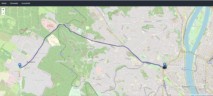
The competitor has selected a route between his place of residence (Budakeszi) and the Széchenyi István University (in Győr), with a distance of approx. 115 km. This means, the scenario does not specifically deal with mobility difficulties within a single city, however, it takes into account and analyses commuting, which necessarily affects more and more people, and obviously deals with mobility challenges. During the creation of the sustainable mobility scenarios, six possible transport modes have been examined, namely: long-distance bus, train, own car, car-sharing, bicycle and walking. A detailed analysis of advantages and disadvantages have been carried out. The scenarios have been evaluated according to an evaluation matrix, containing 5 important factors, namely: emissions during the journey, total duration of the journey, total distance, density of traffic and total costs. All the aspects have been awarded with a point from 0 to 6 (where 0 is the least efficient and 6 is the most efficient). After the scoring the competitor selects the best and most sustainable scenario, which is the electric train combined with additional transport by bicycle.
Civilians Team: “Safely around the University” (Hungary)
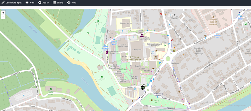
The Civilians Team has selected a relatively short road (approx. 400 m), that starts after a roundabout (connecting Egyetem tér and Vásárhelyi Pál street) and ends at the cross section of streets of Leibstück Mária and Hédervár street. This road connects the parking areas of the university with the main roads of the city. This short road also involves a bus stop (No. 9). Although the road seems to be short, there are several challenges and problems that have been discovered, namely: there is no reliable pedestrian way, the lack of bicycle lanes and the lack of median strip. These problems have been analysed thoroughly, and solutions were also offered. In the MEES application, a user collection was build to show the possible solutions, while the team also supported their ideas with photographs.
From the dormitories of the University, a lot of students cross the roads, in order to take a walk near the riverside, go to picnic, play football or basketball or go to a club. Unfortunately, none of the selected roads has a reliable way of crossing the street. The competitors also calculated the traffic volume with the ADT (Average Daily Traffic) formula, and came to the result of 830 cars/day. As this volume is not that high, there might not be a need to fully build a pedestrian way, however, the building of speed humps would be an essential development for safety. In the name of sustainability, the competitors also looked for a company that make eco-friendly speed humps from 100% recycled plastics.
EGNIRC Team: “Scenarios to get to the shopping mall” (Hungary)
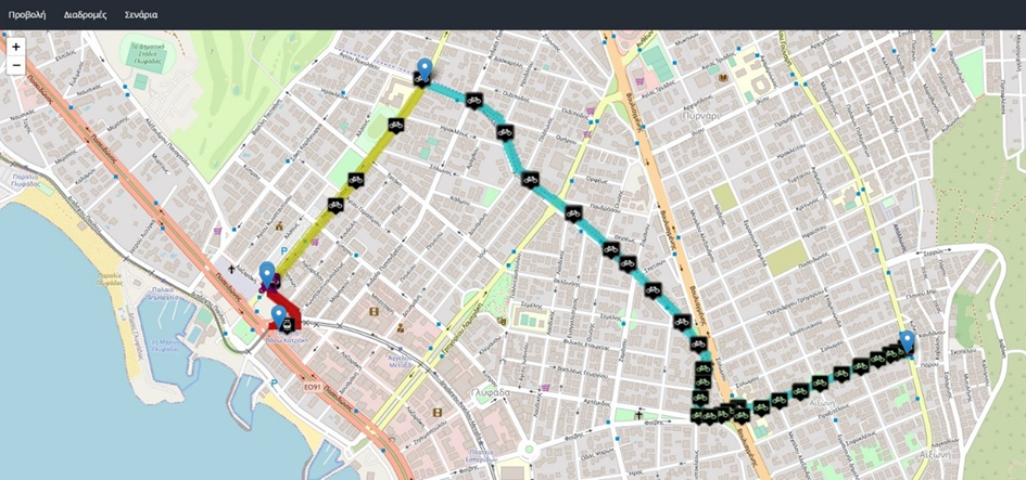
The EGNIRC Team has selected the route from the dormitory to the Árkád Shopping Mall. This is one of the most popular (if not the one) direction for all of the students, who live in the dormitory and want to go shopping. Three scenarios have been selected and analysed, all of them referring to a different transportation mode, namely: cycling, walking and public transport. In the MEES platform, a user collection was build to show the possible obstacles and dangerous points, while this was also analysed through the Siftr application.
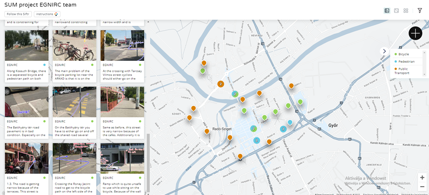
The team has also analysed very extensively the problems and danger points in each of the scenarios. For this, they have used the Siftr application, and their work is available on the following link: https://siftr.org/EGNIRC/ The map contains a list of dangerous points or obstacles, referring to pedestrian traffic (blue), public transport (orange) and cycling (green). The points are visualized with photos, often marked with own illustrations and descriptions.
Tóth Dániel Krisztofer: “Approaching the Industrial Park” (Hungary)
The competitor has selected and analysed a relevant problem, on how to get to the northern part of Győrszentiván (a neighbourhood in Győr) to the Industrial Park of the City, and further to another neighbourhood, Gyárváros. This is a relatively commonly used route, and at the moment, this journey can only be fulfilled with a detour. Part of the route is next to the Audi Factory, and the road traffic conditions are in a perfect state there.
The main idea of the scenario is to create a new road section that would ease the traffic from Győrszentiván towards the Audi Factory and further to Gyárváros. The shortening would mean less emissions, but also would make people to think about moving around with bicycle or on foot. The shortening would also have an effect on public transport, and would make the journey time shorter.
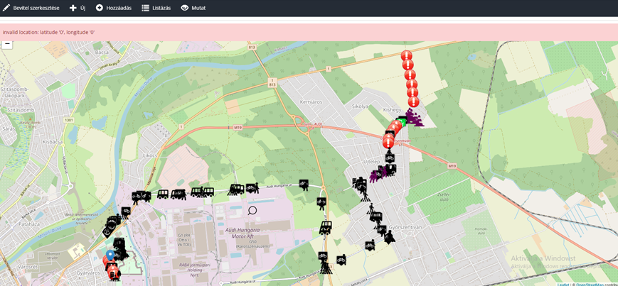
The competitor has used the digital tools extensively. Within the MEES platform, a user collection has been developed, while the new road section has also been created. The scenarios show the utilisation of the shortened road also by bus (public transport), as well as by car.
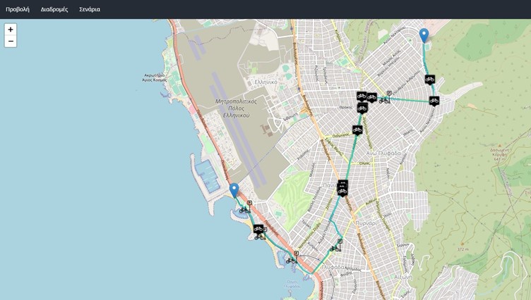
Oramatistes: SUMP in Glyfada (Greece, 1st Place, Winning Scenario)
The competitors selected a route popular to children their age (in secondary education) as well as
many other residents of upper Glyfada who need to access the commercial city centre. The proposed
5 scenarios focused on being practical as well as sustainable. Thus, the creation and continuation of a
cycleway, the creation of a wide pedestrian way, and the use of buses and trams, are aimed at
reducing the emissions of carbon dioxide. In addition, the proposed regeneration of green spaces aim
at enhancing the quality of the environment of the city and especially the atmosphere.
The proposed scenarios also aim at taking into account the special mobility needs of a wide range of
citizens profiles. The second scenario especially focuses on the mobility needs of persons with special
mobility needs like persons with disabilities, senior citizens etc., making use of already existing
infrastructure in combination with small additions. The first scenario focuses on encouraging children
and their parents to use their bikes without fear. The third scenario proposing a wide pedestrian way
at the city centre aims at allowing parents with strollers and small children to enjoy a carefree stroll.
The scenarios utilize the already existing infrastructure and facilities in combination with new ones to
promote SUMP. For example, in the first scenario the proposed new cycleway connects to the already
existing one. In other scenarios, the already existing tram and bus networks are utilized and combined
with walking or cycling.
The scenarios are also aimed at encouraging healthier lifestyles and mobility behaviours. The
proposed extended and continuous cycleway will encourage residents and visitors to cycle, while the
proposed pedestrian way will encourage residents and visitors to walk without fear and exercise while
doing their shopping. The enlargement of the pavements and the creation of more cycleways will
encourage residents to move safely and sustainably.
Finally, the competitors identify obstacles and points on the route where there is a risk for the safety
of pedestrians and cyclists, and make necessary proposals in line with their scenarios.
N. Kladias (Greece, Glyfada)
The chosen route is a typical example of a route followed by large sections of the residents of Upper
Glyfada. The starting point is the open football and basketball court of Terpsithea, as it is a point that
connects the densely populated area of Terpsithea with the foot of the mountain. The specific area
poses difficulties in mobility, since the only routes for public transport (buses) and private cars are the
“central” roads (e.g. Kon. Athanatou Avenue). The end of the route is the beach between the Sailing
Centre and Vergoti Square. This particular point is a popular destination all year round for many of the
residents, for a leisurely stroll along the seafront, or as a destination to relax after visiting the
commercial town centre, for a swim in the warm months of summer, and for a contact with nature in
general. Therefore, in order to accessthe area in the best way according to Sustainable Urban Mobility
principles, appropriate interventions are necessary.
Scenario 1: This specific scenario creates tangible options for mobility for the residents of Upper
Glyfada by bicycle without the need to use a car or other motorized vehicle. Therefore, the use of
motor vehicles is reduced, resulting in reducing the emissions of carbon dioxide.
Scenario 2: It enables persons with mobility difficulties to overcome the “convenient” solution of the
car and limit its use by promoting the use of Public Transport, as long as the Municipality has ensured
their suitability. Again, therefore, the use of private cars is reduced,resulting in reducing the emissions
of carbon dioxide.
Scenario 3: The appropriate interventions on the pavements of the Municipality and the development
of areas suitable for the parking of motorized private vehicles create for the inhabitants of the
municipality an environment that is usable and not overcrowded with cars. In this way, the residents
go from being passengers of private vehicles and Public Transport to the stage of simple pedestrians
and in turn help to reduce the emission of carbon dioxide.
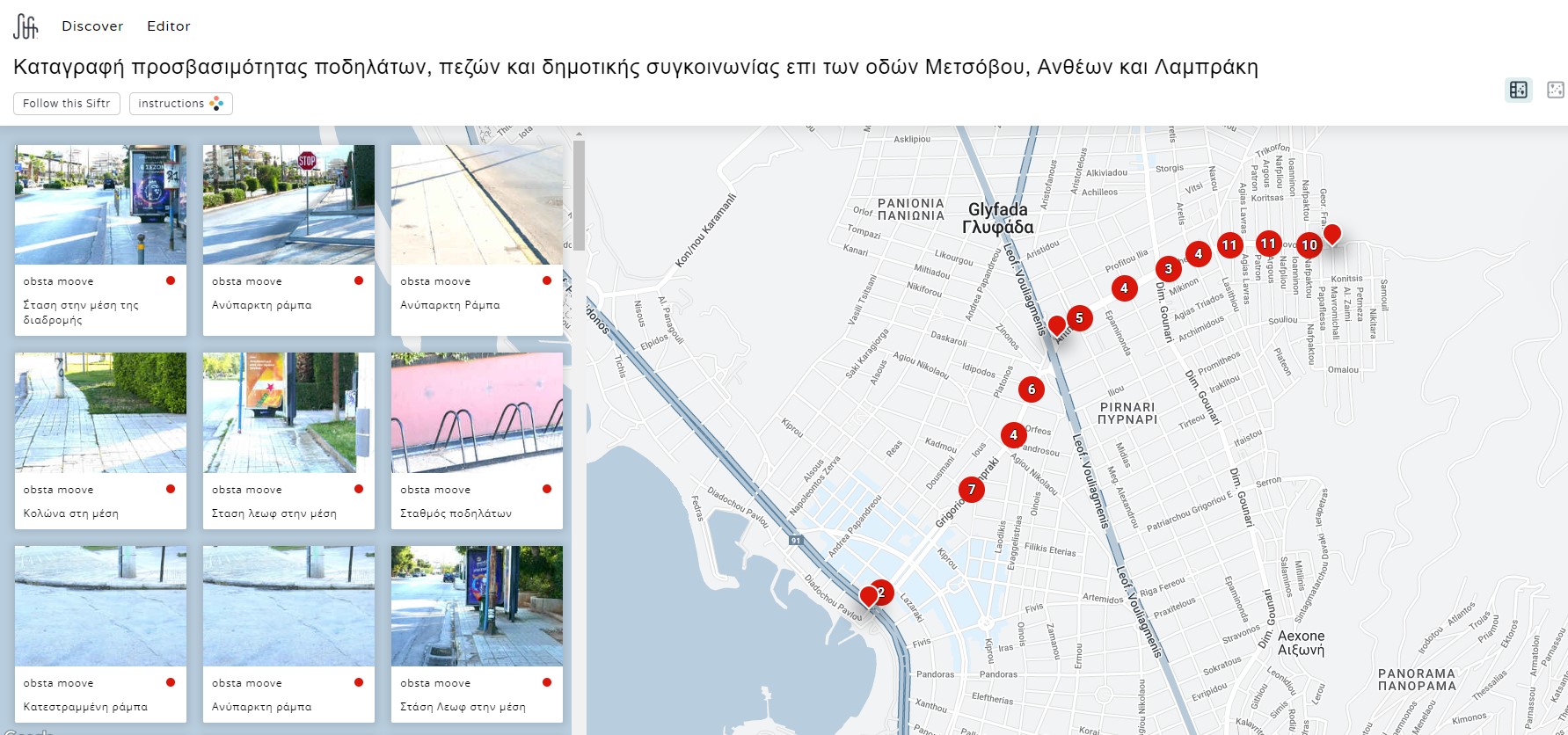
L. Mavronas (Glyfada, Greece)
The route we have selected crosses Glyfada like a backbone; it starts from the foot of the mountain
(Metsovou Street) and reaches the coastal avenue via Antheon and Lambrakis Streets. We selected it
because we use it every day, as we live on Profitou Ilias Street. This route is a confluence of all vertical
roads for all those who want to access the commercial centre of Glyfada and the beach. We go down
very often with our electric and compatible bicycles, experiencing the obstacles along the way.
The main reasons we chose to work on this route are:
It is a busy, important road of our area and we believe it should retain this status and become a
focus for sustainable mobility.
In our study we relied on existing infrastructure in order to reduce construction costs, such as
pavements, ramps, public transport stops.
This route intersects the 2 major cycle-lanes of ‘Ag. Nikolaou’ and ‘Lazaraki’ streets, thus becoming
a natural extension of the existing network of cycle-lanes.
In the event that the centre of Glyfada turns into a car-free area as planned, this route will be the
only natural road leading there.
On a daily basis the route is used by young people on bicycles and electric scooters with the risk of
an accident. We’ve mapped the obstacles and danger points of the route using the Siftr app. Please
find our Siftr at the following link: https://siftr.org/41607/#358934
This intervention encourages the residents of our city and its visitors to leave their cars and access the
city centre by other, sustainable means.
In this way, carbon dioxide emissions are minimized and at the same time they are happy to exercise
while enjoying such a nice ride without a car.
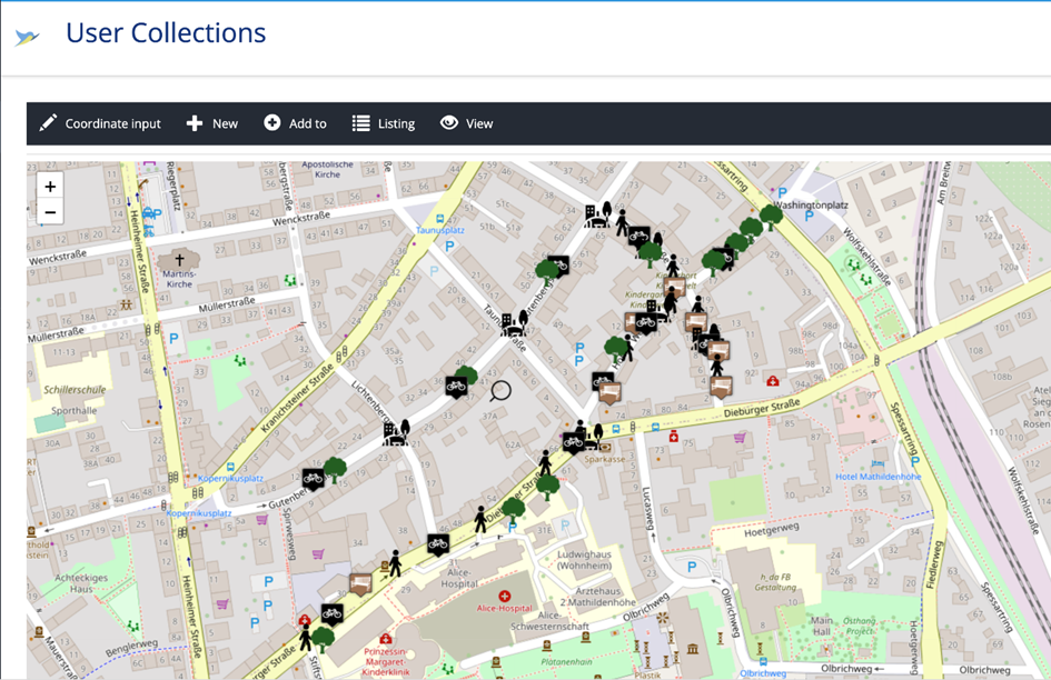
Lanqing Gu: A walkable environment for Martinsviertel (1st Place, Winning scenario, Darmstadt, Germany)
The route Start: Hohler Weg 22, Finish: Dieburger Str.24 (REWE). This route is in my neighborhood connecting residence at the edge of Martinsviertel and local shops. This route is also often used by other residents in all ages, as it also connects a kindergarten and bus station. The objectives of the scenario are to make the neighborhood greener; to encourage people to walk and cycle; reduce car entry into inner neighborhood area. The scenarios are socially inclusive. I have considered the mobility needs of young kids and their parents, older people, and disabled people.
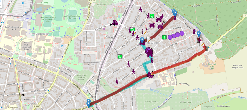
Lakshya Pandit: Komponistenviertel SUMP Scenarios (Darmstadt, Germany)
The scenario includes routes starting from a residential neighbourhood in Darmstadt, i.e. Komponistenviertel towards the city centre via Dieburgerstrasse, which is already prioritized for further residential densification within the city’s 2030 Masterplan. This leads to identifying problems which may arise and focus on interventions which would facilitate a brownfield urban development project. The proposed scenarios are environmentally friendly since:
1. Added routes to reduce cul-de-sacs in the overall street network helps to reduce congestion and have a continuous movement for different user-groups, supporting active movement.
2. New public transport stations add to better access time and added frequency (of buses, trams or rails), encouraging towards a positive shift to active modes and public transport.
3. Addition of a multimodal node (which includes repair station, car-sharing, bicycle sharing, e-scooter services and more) towards an accessible landmark (which is close to different residential units) within the residential neighbourhood, provides better access to sustainable modes and encourages active behaviour.
4. Provision of dedicated pedestrian and cycling pathways on streets having pathway widths below the standards, would add more comfort prior to densification of the neighbourhood which would lead to more congestion and movement restriction between different user-groups.
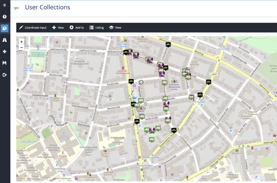
Özge Tasar: Martinsviertel SUMP Scenario (Darmstadt, Germany)
I have chosen a route connection from Martinsviertel to Lichtwiese. I have selected this connection as I find the link ineffective and sustainable. I also think that Martinsviertel has a problem with the many cars seating in the neighborhood. I was always thinking about the solutions when I passed through this neighborhood. After I lived here, I started to observe more the people and their movements and needs. Recently I have seen a new idea about integrating Barcelona’s Superblock idea into the Martinsviertel. It was inspiring for me. That’s why I started my scenarios, Baden, on that. I considered first ”Lichtenbergblock” as a start, which has been already in the idea.
I try to improve the living quality of the blocks by adding a more social point, lights, and keeping the idea of one way for cars. I tried to improve some streets without cars (as I observed many people meet there because of Zucker gallery, or playground area for the kids, and the existing two squares: Riegerplataz and Lichtenberplatz.) I have also added one square with a pedestrian connection. The second scenario is improving the mobility from Martinsviertel to Lichtwiese. As I observe, many students live there besides. Also, Lichwiwese has a kindergarten and urban gardening, forest, sports facilities, swimming pool, and outdoor facilities. If the connection is improved and safe, I think many people would go there by bike and public transportation from this neighborhood. When we look from google earth from ”Lichtenbergblock”/MV to Lichtwiese took nearly 30 min. by bus, 7-10 min. by car, and 10-12 min by cycling. The question is how the bus and bicycle connection would be better. And safe for cyclists and pedestrians. For instance, the L bus option takes so long to go from there. The tram connection is still the same because people need to change the stop. That’s why I offer a new route with another bus line. 3rd scenario will be finding a solution for the connection with tram.
We congratulate all participants of the SUMP Competition!